V
voska89
Moderator
- Joined
- Jul 7, 2023
- Messages
- 42,387
- Reaction score
- 0
- Points
- 36

Free Download CHCNAV Geomatics Office 2023 (2.3.1.20230613) | 677.3 mb
Owner:CHC Navigation (CHCNAV)
Product Name:Geomatics Office
Version:2023 (2.3.1.20230613)
Supported Architectures:x64
Website Home Page :
Code:
https://chcnav.com/System Requirements:Windows *
Size:677.3 mb
The Team CHC Navigation (CHCNAV) is pleased to announce the availability ofGeomatics Office (CGO) 2023 (2.3.1.20230613)is a desktop application software for post-processing GNSS Data, which designed for both static and Post-processing Kinematic (PPK) applications.
CHCNAV Geomatics Office 2.0 what's new
More Processing Modules
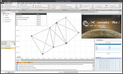
GNSS module is for processing data with Static, PPK and PPP algorithms. RTK module is for editing surveyed features and correcting field coordinates by using PPK post-processing results. Road module is for checking and inputting designed road elements for road stakeout, and UAV data processing module is for getting corrected UAV track coordinates by using both RTK and PPK algorithms.
Fast Post-processing Engine
CGO 2.0 delivers absolute accurate georeferenced positions with faster, reliable and accurate baseline processing and adjustment algorithms. It has ability to process GPS, GLONASS, BeiDou and Galileo static or dynamic data. Besides, it supports intuitive post-processing workflow with quality check, selectable online map and CORS reference data downloading.
Effective Post-processing Function
CGO 2.0 allows for post-processing static and dynamic data with PP, PPK, PPP, DGPS algorithms. It also provides stable and accurate baseline processing result and high-speed processing algorithms for the baseline.
Powerful Adjustment Function
CGO 2.0 supports 3D and constraint network adjustment, users can also configure parameters of data quality, baseline weighting, adjustment methods and network reference factor.
Accurate PPP Solution
CGO 2.0 provides accurate results after processing with auto-downloading of precise ephemeris, it also allows for configuring parameters of observation file, environment and ephemeris.
Seamless Field-to-office Work
Using PPK post-processing results to correct RTK data is available now, users can configure coordinate system, points and features, localisation, base shift, import base maps of imported projects and export for filed application.
Convenient Road Editor
CGO 2.0 supports user-friendly road elements editing with Excel data pasting, allows for editing road centerline, alignments, sections and slopes data along with facilities such as ditch and bridge, and checking road data by coordinates or mileage.
Fast UAV Data Processing
CGO 2.0 allows for getting corrected UAV track coordinates by using both RTK and PPK algorithms, and viewing corrected UAV track coordinates of each capture. Besides, it also supports UAV track display with both positioning data and RTK data.
Extensive Import Files
CGO 2.0 supports .HCN (CHCNAV observation format), .O (RINEX file format), .NOV, .BD9, .D, .N, .G, .C, .L, .P, .HRC files in GNSS module, .csv, .txt, .dat files in RTK module, .rod in Road module, and GNSS data files (.HCN, .O, .NOV, .BD9, .D, .N, .G, .C, .L, .P, .HRC) and UAV positioning data files (.txt) in UAV module.
Extensive Export Files
CGO 2.0 supports reports as .HTML and .txt files in GNSS module, .KML, .SHP, .DXF, .HTML, .csv, and .RAW files in RTK module, .dat, .csv, .KML and .KMZ files, .txt files in UAV module, and allows for saving the road file as a .rod file in Road module.
Various Base Maps
CGO 2.0 have access to process data with various online maps (Bing Map, OSM, WMS and WMTS) and offline base maps (.DXF, .SHP and .SIT).
Embedded Help Tools
CGO 2.0 allows for calling out user guide and work flows by one click, and viewing the software information. Besides, it supports modular registration and display control.
More Intuitive Interface
CGO 2.0 allows for following the ease-to-use interface to complete workflow, and viewing guidance in the user-friendly message box. It also has ability to customise layout and modules displaying which makes the software adapt to your working habits.
More Tools
CGO 2.0 offers access to different tools to make office work easier, including coordinates converter, antenna manager, TIFF map compressor (SIT), angle calculator, distance and volume calculation functions, RINEX converter and observation split and merge tools.

CHCNAV Geomatics Office Software (CGO)is a powerful office software solution, designed for engineers as an integrated platform to make a link between field and office workflow from multiple sensors and generating rich deliverables. It supports 4 modules: GNSS, RTK, road and UAV, which allows for processing massive fieldwork data in one software.
CHCNAV | CGO 2.0 Baseline Processing
Watch our CGO 2.0 Tutorial video to learn how to efficiently and accurately process a GNSS baseline.
Founded in 2003,CHC Navigationcreates innovative GNSS navigation and positioning solutions to make customers' work more efficient. CHCNAV products and solutions cover multiple industries such as geospatial, construction, agriculture and marine. With a presence across the globe, distributors in more than 120 countries and more than 1,500 employees, CHC Navigation is today recognized as one of the fastest growing companies in geomatics technologies.
Recommend Download Link Hight Speed | Please Say Thanks Keep Topic Live
Rapidgator-->Click Link PeepLink Below Here Contains Rapidgator
http://peeplink.in/a8d0f7bc4355
Uploadgig
207d8.CHCNAV.Geomatics.Office.2023.2.3.1.20230613.rar
NitroFlare
207d8.CHCNAV.Geomatics.Office.2023.2.3.1.20230613.rar
Links are Interchangeable - No Password - Single Extraction
